This template provides a tool to standardise fish passage action plan steps and provide regional councils with guidance on developing plans to fulfil fish passage requirements.
This guidance document supports the Fish passage action plan template. It provides councils with guidance for developing fish passage action plans. The document covers information on overarching freshwater ecosystem objectives and legal requirements and provides background knowledge and considerations specific to the wider fish passage work programme.
As New Zealanders, it is our duty to look after our fresh water, the life it sustains and the interconnected ecosystems it supports. Since human arrival in New Zealand, these systems have undergone significant detrimental changes. Unfortunately, the adverse effects on the wellbeing of the environment are felt by everyone: te taiao (the earth, sky, air, water and life that is all interdependent), indigenous Māori and pākeha.
76 per cent of indigenous freshwater fish species (39 of 51) are threatened with extinction or at risk of becoming threatened. (Stats NZ, 2021)
Indigenous fish (such as tuna (eels) and inanga (whitebait)) and regionally desirable sports fish (such as trout and salmon) move between freshwater habitats to reach food and spawning environments and maintain their populations. Other freshwater species, such as shrimp and aquatic invertebrates, also move within waterways to eat and breed. If the movements of these species upstream and downstream are delayed or prevented, they may not be able to reach the habitats they need to complete their life cycle, and so may decline or be lost from the waterways.
Structures, such as culverts, dams, weirs, fords and tide gates, can delay or prevent fish movement and stop them from accessing critical habitats. This loss of habitat connectivity is partly why many indigenous freshwater fish species are threatened or at risk of extinction.
Why a fish passage action plan?
To meet our obligations to revitalise te taiao to achieve target attribute states and environmental outcomes, we need to have a plan in place. The National Policy Statement for Freshwater Management 2020 (NPS-FM; section 3.15 and section 3.26) requires regional councils to prepare a ‘fish passage action plan’. The plan must include methods to:
- identify the cause of the stream degradation
- identify actions to address those causes
- develop a plan to monitor the effectiveness of any mitigation actions.
Purpose of this guidance document
This guidance document helps councils to correctly interpret the technical requirements of the new fish passage policies and regulations in the NPS-FM 2020.
Some councils already have their own specific fish passage requirements and policies in place, so this guidance has been written to allow for flexibility. Councils will need to revisit and adapt action plans to reflect any new initiatives and funding opportunities in their regions.
This guidance on developing fish passage action plans is for councils to use to apply to their context. With the support of this guidance, and council examples, councils will:
- gain a better understanding of how to develop an action plan for fish passage and what should be considered when developing the action plan
- have the tools to produce useful, simple and accessible action plans that help map and provide good fish passage.
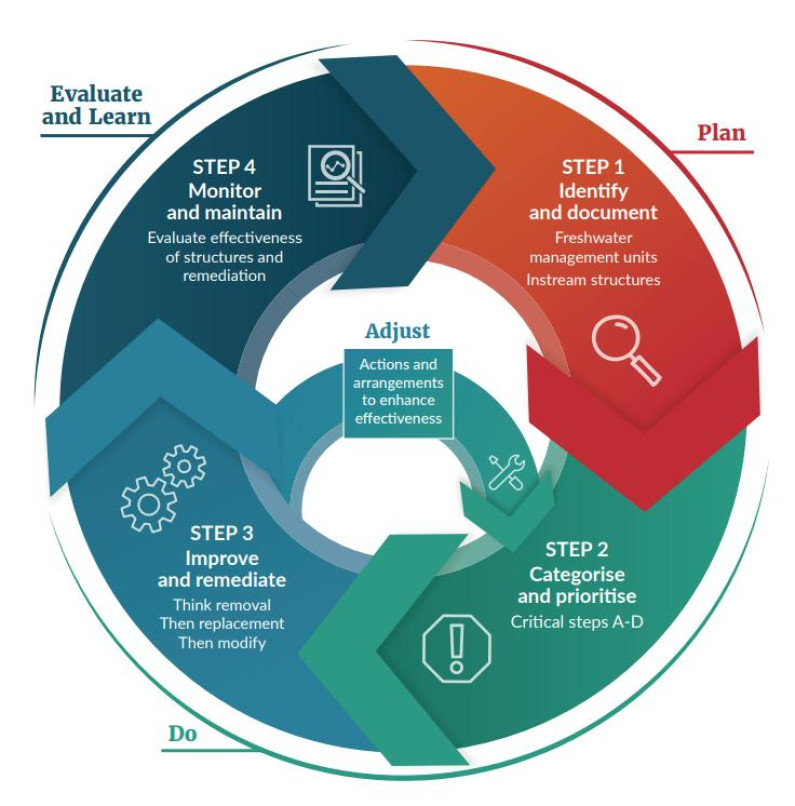
The action plan is applied in four steps, as shown in figure 1.
Figure 1: Four steps towards a fish passage action plan, following the adaptive management cycle for fish passage assessment and remediation
Te Mana o te Wai, ki uta ki tai and mahinga kai: Successful fish passage provision through integrated catchment management
The main goal of district plans is to make sure the plan framework prioritises the health and wellbeing of water bodies and freshwater ecosystems above any other use of, or demand on, fresh water. This objective is described below:
The NPS-FM 2020, Part 2: Objectives and policies, 2.1 Objective:
…ensure that natural and physical resources are managed in a way that prioritises:
- a) first, the health and well-being of water bodies and freshwater ecosystems
- b) second, the health needs of people (such as drinking water)
- c) third, the ability of people and communities to provide for their social, economic, and cultural well-being, now and in the future.
The Fish passage action plan template supports this objective by recognising that all natural and physical resources need to be managed in an integrated manner, enabling catchment-based planning to achieve better environmental outcomes.
Te Mana o te Wai
In the NPS-FM 2020 Te Mana o te Wai is the fundamental concept that expresses the importance of the special connection New Zealanders have with fresh water. By protecting the health of fresh water, the health and well-being of people and ecosystems are also protected. More information about the concept and framework of Te Mana o te Wai can be found in section 1.3 of the NPS-FM 2020.
When managing fish passage, Te Mana o te Wai ensures the health and wellbeing of the water, including all life within, is protected and human needs are provided for before enabling other uses of water. For New Zealand’s fresh water to be healthy, fish need to be able to move freely between and within freshwater ecosystems.
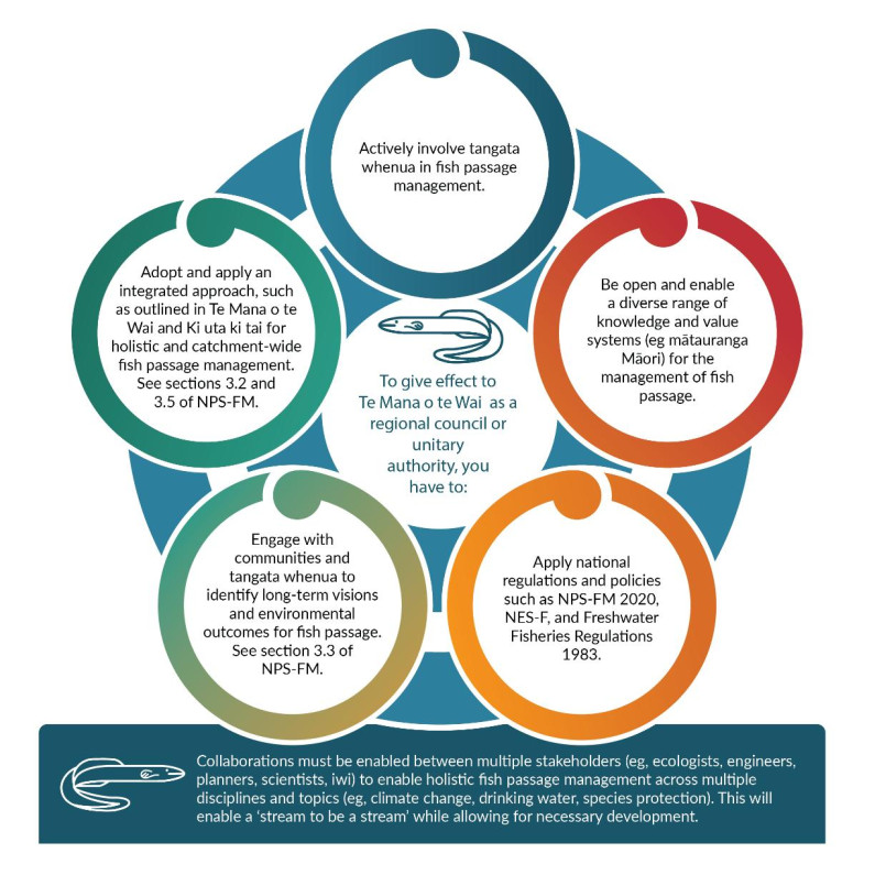
Every regional council must develop in its regional fish passage policy statement a long-term vision that gives effect to Te Mana o te Wai (figure 2).
Figure 2: How regional councils must give effect to Te Mana o te Wai
Ki uta ki tai
Ki uta ki tai (adopting an integrated framework) is another relevant concept that needs to be included in fish passage action plan to successfully manage fish passage. The ki uta ki tai approach views the world through a te ao Māori lens, based on the idea that if the realms of Tāwhirimatea (the god of weather), Tāne (the god of forest), Papatūānuku (Earth mother) and Tangaroa (the god of the ocean) are sustained then the people will be sustained. Each realm connects to and relies upon one another. While the general meaning of ki uta ki tai is ‘from the mountains to the sea’, the kupu (message) and understanding will need to be determined by mana whenua.
The ki uta ki tai concept is particularly important for fish passage remediation, where fish migrate in both directions: from the mountains to the sea and back. Applying the idea of ki uta ki tai to fish passage barrier remediation allows catchment-wide management of the cumulative effect fish passage barriers have in an entire catchment.
Mahinga kai
Mahinga kai values include species, natural habitats, materials and practices used for harvesting food, and places where food or resources are, or were, gathered. Mahinga kai is about the value of natural resources that sustain life, including people. It is important to manage and protect these resources in the same way that ancestors have done before us. Mahinga kai areas are special places that need to be taken care of for their environmental or biodiversity significance.
Freshwater fish are mahinga kai and a staple food resource. They include species such as tuna and hao (longfin and shortfin eel), kanakana and piharau (lamprey), pātiki (flounder), aua (yellow-eyed mullet), kēwai and waikōura (freshwater crayfish), paraki (smelt), mata (whitebait) and kākahi (freshwater mussel).
Legal requirements
Three main national policy and regulatory obligations are in place that require regional councils to provide for fish passage:
- Resource Management (National Environmental Standards for Freshwater) Regulations 2020
- Freshwater Fisheries Regulations 1983
- National Policy Statement – Freshwater Management 2020.
These requirements have separate purposes, and one does not take precedence over another.
Resource Management (National Environmental Standards for Freshwater) Regulations 2020
The Resource Management (National Environmental Standards for Freshwater) Regulations 2020 (NES-F), under the Resource Management Act 1991 (RMA), contains set rules that apply to installing or altering a culvert, weir, flap gate, dam or ford. The regulations require applicants to provide information about any new structures being planned with potential to block or impede fish passage to the regional council.
Rules for fish passage vary across the country, so it is essential to refer to local plan policies and rules to understand local legislative requirements and responsibilities. More information on legal requirements can be found in section 2.4 (p 23) in the New Zealand Fish Passage Guidelines (Franklin et al, 2018) [NIWA, 8.7 MB].
Consenting and compliance
Regional plans set rules for the use of resources within a region, and no person may use land, water, air or the coastal marine area in a manner that contravenes a regional rule (for a permitted activity) without holding a resource consent. If instream structures are not a ‘permitted activity’, resource consents for fish passage remediation may be needed.
Global (bundling) consents
As different sites can involve several similar activities and are likely to involve similar effects on the environment, global consenting (also referred to as bundling) can provide efficiencies. However, global consenting can sometimes delay the granting of consents where activities involve a greater degree of scrutiny on the level of effects and assessment than others, or where the project design or land owner approvals have not progressed sufficiently. Global consenting requires assessments to be as thorough and case-by-case specific as individual resource consents.
Council examples
Auckland Council
Table 2 in ‘Auckland Council Healthy Waters Fish Passage Remediation – Planning Assessment Summary; 2021’ summarises likely resource consent, approval and engagement requirements for sites where fish passage remediation has been identified. Further information including assessments of consenting triggers, can be found on the Fish Passage Hub.
Environment Canterbury
Global consents (www.ecan.govt.nz/data/consent-search) exist in the Canterbury region for:
Built barriers:
- CRC172229 [ECAN] – Install Structure in Bed/Maintain Structure in Bed/Remove Structure in Bed
- CRC172538 [ECAN] – Damming of Water and Temporary Diversion of Surface Water
- CRC172539 [ECAN] – Discharge Water into Water
Spat rope installation:
- CRC155586 [ECAN] – To erect or modify a structure in the bed of a river or to excavate and disturb the bed of a river
Barrier removal, remediation or replacement in progress
- CRC222266 [ECAN] – To remove, install, remediate and maintain structures to provide for fish passage and to remove and plant vegetation in, on or over the bed of a waterway
- CRC222267 [ECAN] – To undertake earthworks on the banks or in the immediate riparian margin of the waterway
- CRC222268 [ECAN] – To temporarily dam a waterway and to take surface water
- CRC222269 [ECAN] – To discharge contaminants or water to water
- CRC222270 [ECAN] – To undertake works in the coastal marine area
Freshwater Fisheries Regulations 1983
The Department of Conservation is responsible for enforcing the Freshwater Fisheries Regulations 1983 [Legislation New Zealand], under which any culverts, fords, dams and diversion structures in natural rivers, streams or water may need approval. This includes considering exemptions for fords or culverts that impede fish passage, approving any structural changes to fish facilities, and assessing whether proposed dams and diversion structures require a fish facility. A full copy of the regulations can be found here [Legislation New Zealand]. Further information and application forms can be found on the Department of Conservation website.
National Policy Statement for Freshwater Management 2020
The NPS-FM 2020 [Ministry for the Environment, 795 KB] requires councils, under section 3.26, to produce an action plan to provide for fish passage and include the objective goal (in the NPS-FM 2020, Part 2: Objective and policies, 2.1 Objective) in their regional plans (or words to similar effect) as soon as possible. Other NPS-FM 2020 sections relevant to fish passage include: 3.9 Identifying values and setting environmental outcomes as objectives, 3.12 How to achieve target attribute states and environmental outcomes, 3.15 Preparing action plans, 3.20 Responding to degradation, 3.30 Assessing and reporting, and appendix 2B Attributes requiring action plans.
Roles and responsibilities
Fish passage barrier remediation is a legislative requirement under the Freshwater Fisheries Regulations 1983 and the RMA and must be met. This means Department of Conservation (DoC) approval could be required for the installation, maintenance or alteration of instream structures in New Zealand waterways. DoC will consider if any new dam or diversion structure will require a fish facility, approve any structural change to an already approved dam or diversion structure with a fish facility and consider any culvert or ford that impedes fish passage and if this is appropriate. Councils are responsible for compliance monitoring and enforcement through regional plans. Rules in regional plans include providing fish passage and protecting places that are important habitats for native species. Because regional rules for fish passage vary across the country, it is essential to refer to regional plan policies and rules to understand local legislative requirements and responsibilities.
Other national Acts and regulations that may apply should also be considered when designing and managing physical structures (eg, the Building Act 2004, Railways Act 2005, Local Government Act 2002).
Further information on legislative requirements can be found in section 2.4 and appendix A of the New Zealand Fish Passage Guidelines (Franklin et al, 2018) [NIWA, 8.7 MB].
Council examples of what the implementation of this legislation may look like can be found on the Fish Passage Hub.
Freshwater Fisheries Regulations 1983, Regulations, 2 Interpretation (1) [Legislation New Zealand]:
“Fish facility means any structure or device, including any fish pass or fish screen inserted in or by any water course or lake, to stop, permit, or control the passage of fish through, around, or past any dam or other structure impeding the natural movement of fish upstream or downstream”
Preparing action plans
The NPS-FM sets out the following policy for preparing action plans:
- Action plans prepared for the purpose of this National Policy Statement may:
- be prepared for whole FMUs [freshwater management units], parts of FMUs, or multiple FMUs (see STEP 1); and
- set out a phased approach to achieving environmental outcomes (see STEP 4); and
- be ‘prepared’ by adding to, amending, or replacing an existing action plan.
- An action plan may describe both regulatory measures (such as proposals to amend regional policy statements and plans, and actions taken under the Biosecurity Act 1993 or other legislation) and non-regulatory measures (such as work plans and partnership arrangements with tangata whenua and community groups) (see this chapter).
- If an action plan is prepared for the purpose of achieving a specific target attribute state or otherwise supporting the achievement of environmental outcomes it must:
- identify the environmental outcome that the target attribute state is aimed at achieving (see STEPS 1 and 4); and
- set out how the regional council will (or intends) to achieve the target attribute state (see STEPS 1 and 4).
- Action plans:
- must be published as soon as practicable; and
- may be published either by appending them to a regional plan or by publishing them separately.
- Before preparing an action plan or amending an action plan other than in a minor way, the regional council must consult with communities and tangata whenua (see this chapter).
- Every action plan, or part of an action plan, prepared for the purpose of this National Policy Statement must be reviewed within 5 years after the action plan or part of the action plan is published (see STEP 4).
Best information available
The NPS-FM (section 1.6) requires the use of best information (that is, complete and scientifically robust data) available at the time.
In the absence of complete and scientifically robust data, the best information may include information obtained from modelling, as well as partial data, local knowledge, and information obtained from other sources, but in this case local authorities must:
- prefer sources of information that provide the greatest level of certainty; and
- take all practicable steps to reduce uncertainty (such as through improvements to monitoring or the validation of models used).
Links to important guidance documents and webpages (eg, legislation, factsheets or lessons learnt, essential steps) are provided in the Fish Passage Hub, to ensure councils have the best information available to create a robust fish passage action plan.
Collaboration and linkages are essential
Collaboration within and between councils, government agencies, industry and other national initiatives and policy development can increase efficiency and create new knowledge, even when there are different regional fish passage management objectives and performance standards. Examples of collaboration are provided in the next section. For fish passage to be managed holistically, linkages to other freshwater management programmes and initiatives should be considered.
Collaboration within councils: Examples
Greater Wellington Regional Council has set up a Freshwater Response Team with internal cross-council sub-groups, one being the Fish Passage Working Group to manage fish passage in a collaborative way in their region. This Fish Passage Working Group includes people from environmental regulation (consenting), environmental science, parks, flood protection and environmental policy and communications departments. The group has worked through all the NPS-FM and NES-F fish passage requirements and identified tasks to work on to achieve these requirements. The group meet on a six-weekly basis to monitor progress and its lead must report back to the Freshwater Response Team on progress, identifying any risks and issues that need to be addressed. The group has been helpful because it brings together people with the expertise required for successful fish passage management.
Collaboration between your council, private landowners and community
Private landowners will need to be approached to achieve area-wide identification and documentation of fish passage barriers. Many fish passage barriers are on private land, and, without remediating these, catchment-wide connectivity is unlikely to be achieved. Private land owners include organisations (eg, Waka Kotahi, DoC, KiwiRail) as well as individuals.
Linkages to other initiatives
For fish passage to be managed holistically, links to other freshwater management programmes and initiatives should be considered, such as:
- national policies and regulations, eg:
- New Zealand’s Climate Change Programme, [Ministry for the Environment]
- Three Waters Reform Programme, [Three Waters Reform, Department of Internal Affairs]
- Regulations for freshwater farm plans [Ministry for the Environment] (under development as at February 2022) and
- Stock exclusion regulations [Ministry for the Environment]
- Measurement and reporting of water takes amendment regulations, Ministry for the Environment]
- Water conservation orders [Ministry for the Environment]
- Marine pollution regulations) [Ministry for the Environment]
- community projects or catchment care groups (eg, NZ Water Citizens [NZ Water Citizens], Tasman Environmental Trust [Tasman Environmental Trust])
- industry initiatives (eg, Living Water [Living Water], NZ Landcare Trust [NZ Landcare Trust]).
Early engagement with mana whenua is essential for ensuring all knowledge is considered when managing fish passage in your council. We have provided further information on engagement with mana whenua in the Te Mana o te Wai section of this document.
Privacy considerations
Privacy and confidentiality need to be considered when identifying instream structures in your region. A privacy statement can help explain how your council deals with any personal information (that is, information about an identifiable individual) collected during the fish passage assessments.
This statement needs to clearly outline:
- WHAT personal information will be collected
- the PURPOSE of, and REASONS for, the information being collected (in this case, fish passage assessment on private land)
- how the information will be STORED, PROTECTED and SHARED
- where landowners can find more INFORMATION and who to CONTACT.
An example is given on the Fish Passage Hub of how Greater Wellington Regional Council has approached private land owners.
Risks for implementation of action plans
It can be useful for councils to rank low-to-high risks for implementing their fish passage action plan and address them accordingly. Risks could include blocks to intended outcomes, such as:
- lack of support from landowners (eg, denial of access to their land)
- major weather events (eg, damage to instream structures to be remediated)
- change of council internal funding (eg, removal of funding commitment by council)
- lack of workforce (eg, limited number of trained assessors or qualified remediation contractors)
- lack of information on the success or durability of remediation options (ie, structures ‘remediated’ but that perhaps did not achieve the positive ecological outcomes intended).
Every council must prepare an action plan to support the achievement of the fish passage objective contained in the NPS–FM (outlined previously).
A work programme in an action plan must, at a minimum:
- identify instream structures in the region by recording, for each structure:
- all the information in Part 1 of Appendix 4; and
- any other information about the structure, such as the information in Part 2 of Appendix 4; and
- evaluate the risks that instream structures present as an undesirable barrier to fish passage; and
- prioritise structures for remediation, applying the ecological criteria described in table 5.1 of the New Zealand Fish Passage Guidelines (see clause 1.8); and
- document the structures or locations that have been prioritised, the remediation that is required to achieve the desired outcome, and how and when this will be achieved; and
- identify the structures that have been remediated since the commencement date; and
- specify how the ongoing performance of remediated structures will be monitored and evaluated, including the effects of the structure on the abundance and diversity of desired fish species.
The Fish passage action plan template sets out a four-step process for councils to follow to establish effective fish passage action plans. This section of the guidance gives further detailed information on each of the four steps.
This section outlines fish passage management strategies in the context of freshwater management units (FMUs) and how to document information on instream structures into a data repository.
Identify freshwater management units and associated management strategies
Freshwater management units
Every regional council must identify FMUs for its region, and every water body in a region must be located within at least one FMU. An action plan can be prepared for all or part of an FMU or for multiple FMUs and is intended to outline a staged approach to achieving the relevant target attribute states and environmental outcomes (that is, plan objectives) to which they relate. Table 1 summarises potential cultural and social considerations that could help identify FMUs.
Table 1: Potential considerations for identifying freshwater management units
|
Consideration |
Explanation |
Examples |
|
Cultural and social characteristics of a region |
Councils should consider cultural, social and political boundaries, because these may influence how well water users, mana whenua, and the community identify and connect with freshwater management issues. |
Ki uta ki tai [ORC] – Otago Regional Council freshwater management unit setting Whaitua [GWRC] – Greater Wellington Regional Council, or Fish Passage Hub [MfE] Mahinga kai sites (see Fish Passage Hub) |
|
Freshwater values |
Values that may apply in a national, local or regional context can include:
|
Waipaoa FMU [GDC] – Gisborne District Council Sites of ecological significance (eg, Christchurch district plan) Department of Conservation’s ecosystem management units and species management units [DoC] Ngā awa rivers [DoC] |
Further information on FMUs can be found in the Ministry for the Environment’s Guide to freshwater management units [Ministry for the Environment, 656 KB, 2016], and specific requirements are listed in the NPS-FM 2020 [MfE, 795 KB] (section 3.8).
Identify and document instream structures
Where do I start with documenting instream structures?
An initial assessment is an important first step, as it will identify potential barriers early on, help communicate the scale of the issue to others and inform initial budgeting and work plans. As part of the initial assessment, the following details should be known and recorded for all structures (such as culverts, weirs, fords, dams, aprons, ramps and flap gates), to assess their location and current state:
- geographical co-ordinates of structure
- date and time of survey
- hydrological information (eg, flow (no flow, low, normal, high, unknown) and velocity when survey was completed (low velocity recirculation zones, backwater distance))
- whether the stream is tidal where the structure is located (yes, no, unknown)
- the width of the river at the water’s surface and the width of the bed of the river
- structure type (eg, culvert, weir, ford) and structure add-ons
- photos viewed upstream and downstream at both ends of the structure.
Further insight on required information for all culverts, weirs, fords, dams, aprons, ramps and flap gates is listed in the NPS-FM 2020 [MfE, 795 KB] (see appendix 4 – Part 1, and for additional optional information, appendix 4 – Part 2).
Existing structures were estimated to be the main reason for impeding fish passage within a region, due to poor installation or inadequate maintenance. For example, based on Auckland’s watercourse assessment reports completed in 2021, over 1,000 potential barriers to fish passage were identified that are associated with existing council-owned stormwater infrastructure and assets (C Brent, Auckland Council, pers. comm., 13 September 2021).
Greater Wellington Regional Council identified 660 fish passage barriers [Scoop] in Kāpiti Coast waterways across public and private land in 2021.
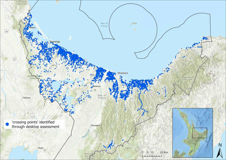
Bay of Plenty Regional Council identified 11,683 crossing points across the region (E Bocker, Bay of Plenty Regional Council, pers. comm., 15 September 2021), and 1,614 structures, or 36 per cent, of total potential public road crossings were assessed in six territorial authority areas of the Waikato region between 2000 and 2005 (see Fish Passage Hub).
Defining objectives and performance standards
The information compiled during the initial assessment should be used to define ecological objectives. Defining clear objectives based on initial assessments is an integral part of managing instream structures for fish passage. The objectives inform the development of the biological, hydraulic and cultural performance standards against which the structure can later be evaluated. Because each site is unique, individual solutions are needed in each location. As a first filter for defining objectives, we recommend a hierarchical approach that considers:
Go broad: Clearly define broad-level ecological and cultural objectives for the ecosystem (eg, “restore or sustain fish distribution and abundance for a healthy te taiao”). Likely target species should be identified, their estimated abundance and distribution, the recovery potential of species that have been in decline, the life stages that are migrating, and when and under what conditions those migrations take place.
Go local: Define site-specific fish passage objectives (eg, “The structure must allow juvenile inanga to pass between August and January.”).
Go focused: Define more detailed biological performance standards (eg, “How can fish passage success be measured at a structure?”) and hydraulic and physical performance standards (“What are water velocities or turbulences like at a structure?”). Biological performance standards define how fish passage success can be measured at a structure. This may include things such as the movement of particular species or size classes through or across the structure, or changes in the upstream fish community. Hydraulic performance standards define the envelope of hydraulic and physical characteristics of the structure; that is, the specific characteristics (eg, water velocity or turbulence) that if provided will lead to the biological performance standards for the structure being met.
More specific information on biological and hydraulic performance standards can be found in section 3.1 (p 25) and section 3.2 (p 25) of the New Zealand Fish Passage Guidelines (Franklin et al, 2018) [NIWA, 8.7 MB].
Combine all structure information within a region to one repository
Managing fish passage in your region will be an ongoing process. It is therefore critical to have a robust system that lets you record what type of instream structures are present in your region, the state they are in, and the risk they present to fish passage. Your documentation system also needs to allow for flexibility, because circumstances are likely to change (eg, structures may become redundant, fish species management priorities change in the stream network, asset owner changes).
Many councils have already established documentation processes with extensive geospatial databases. Examples of existing council processes are provided in the Fish Passage Hub. For councils that have not already established a robust system or would like to change or adapt theirs, we recommend the New Zealand Fish Passage Assessment Tool (FPAT). [NIWA]
Fish Passage Assessment Tool
The Ministry for the Environment supports and endorses the use of the FPAT [NIWA] as the main tool to help councils with fish passage compliance, monitoring, and enforcement (CME) in New Zealand. The tool provides practical approaches to identify, document, prioritise and maintain instream structures in New Zealand and fulfils the NPS-FM 2020 and other national policy and legislation requirements. The FPAT includes a mobile app to capture data about structures in the field, a database where all data submitted using the app are stored, and a web tool where the data in the database can be publicly viewed and downloaded. The mobile app is free and available for a range of operating systems. It can be accessed on the NIWA website.
The FPAT can be used by regional councils to meet their data collection and storage requirements under Subpart 3 of the NES-F and section 3.26(7a) of the NPS-FM.
The FPAT may have sections not applicable to certain councils in certain circumstances, and many councils may have developed their own systems that comply with legislative fish passage assessment requirements (eg, fish passage assessments that started before the FPAT was developed). Recommendations and guidance are provided in this section on how to use historical structure data, in conjunction with the FPAT, and applicable council examples are given on the Fish Passage Hub.
We recommend the FPAT is used to record structures and their relevant details as required, to provide river connectivity. FPAT currently records the following metrics, which align with the NPS-FM recommendations:
- date and time of a survey, survey location, NZSegment number (from the River Environment Classification), organisation entering the data
- river conditions (ie, flow, tidal, stream width, bankfull width)
- structure generic information (ie, structure type, asset ID number and asset owner)
- structure-specific information for culverts, fords, weirs, dams, flap gates, pump stations, natural barriers, bridges
- structures that have been removed or had any structural add-ons, such as aprons, ramps, wingwalls and screens (the FPAT has the option to identify structures that may have already been remediated; this includes replacement, alterations or removal of the original structure)
- photos of structures and stream conditions
- risk to fish passage (priority, calculated and observed risk)
- FPAT ID and Parent ID (see ‘FPAT upgrades’).
More detailed information on how to acquire, install and use the tool is given in the Fish Passage Assessment Protocol mobile application – User Guide (FPAT User Guide) (Franklin, 2018) [NIWA]. A video and information sheet will also be available in April 2022.
Important considerations when using the FPAT application
Although we endorse FPAT as the main mechanism for consistent collection of instream fish passage information, we realise some councils have used or are planning to use different tools to assess instream structures. The decision on which tool to use lies with each council, if the information collected covers NPS-FM requirements.
The current version of the FPAT app (Version 1.4.1) has limitations, and assumptions have been made that may influence the robustness of the risk and prioritisation score calculations. This may subsequently have influenced a council’s decision to use the tool. Limitations and assumptions are given below.
Barrier prioritisation score
- The barrier prioritisation score for any structure is influenced by the location and passability of other structures in the same catchment, so it can vary as more structures are identified and assessed, or as other barriers are removed or remediated. Because of this, uncertainty can exist in the score if all barriers in a catchment have not been identified or assessed.
- At present, the barrier prioritisation score does not consider the suitability of upstream habitats for supporting fish communities, instead assuming more accessible stream length, regardless of its quality, is equally beneficial. Habitat suitability varies between reaches for different species. Metrics incorporating habitat suitability may be added in future.
- Measures are currently not included that assess stream depth upstream or downstream of the structure to provide additional information on potential fish habitat.
- Other factors that may influence the decision to remediate one structure ahead of another are currently not included in the FPAT score calculations (eg, the cost of the fix required, the age and condition of the structure, whether the catchment is conservation land or heavily modified, cultural or recreational values, and accessibility and structure ownership, amongst other factors, could all contribute to determining the relative value of remediating a structure).
- Priority scores can currently only be updated if information about a structure is updated in the database (ie, by assessing a structure that was previously unassessed or by updating the assessment of an existing structure in the database). Whether a priority score can be updated depends on the type of extra information collected by councils. The information can be used to feed into the FPAT priority score once submitted to the database. Incorporating a council’s own priority scores into the FPAT is not an option at present. This would undermine the integrity of the data in the database by creating inconsistencies in the scores. Instead, this would have to be resolved by developing an internal council process for overwriting the individual scores wanting to be changed and recalculating scores.
Barrier risk assessment
- The FPAT app currently includes assumptions that may oversimplify the structure assessment for some structures (eg, all bridges are assumed to be very low risk; dams, pump stations and flap gates are assumed to have a high to very high risk). This could be improved over time by including additional structural data into the risk assessment for a wider range of structures.
- Only structures that have been identified and assessed can be incorporated in the risk calculations. Where a full census of structures has not been carried out, the number of structures will be underestimated. As the sample size increases, however, it is likely the proportion of barriers that occur in each risk class may be representative of the catchment (or larger spatial unit) as a whole.
If a fish passage assessment has not been identified or tagged to a digital river network during assessment (ie, NZSegment from the River Environment Classification [NIWA]) then priority and risk cannot be calculated for this structure. This has been found for some small streams not mapped in the app, resulting in no risk assessment of these streams.
Privacy considerations
Many fish passage barriers are on private land. At the time of writing, the Ministry for the Environment is assessing how structure information can be safely stored and portrayed in the FPAT while considering privacy and confidentiality of asset and landowners. See Privacy considerations, for more information and how to address this topic.
Open-source data
The data contained in the FPAT are open-source data. The quality of the data contained in the tool may, therefore, vary, depending on the level of training the assessor has had (see Training and experience).
FPAT upgrades
The Ministry for the Environment is funding the long-term hosting and support of the FPAT and improvement upgrades, to ensure the tool is consistent with NES-F and NPS-FM requirements. Improvements to the current FPAT version have started and upgrades have been made, based on user testing and feedback. These upgrades are discussed below.
Application programming interface (API) development: an API has been implemented that lets end users directly extract data from the FPAT database. End users can extract FPAT data in either a static CSV batch format or on demand using a GeoServer API. Users can filter their data requests by date range, geographical location and structure type, and are able to request inclusion of full site histories and/or deleted records. We understand several regional councils are making use of this facility to incorporate FPAT data into their own geospatial data systems. The API will be available, once final testing and security checks are complete, at: https://fpat-api.niwa.co.nz.
Search page: This has been added to the FPAT webtool and lets users filter results returned via the manual CSV download. This means users who do not have the expertise or need to use the API can still access the filtering functionality provided by the API.
Provide for download of records captured over time: Previously, users were only able to download and access the most recent survey from any given site. Now, full site histories (ie, all records in the database for a site) can be downloaded through the API or webtool search page. Site history information is accessed through the Parent ID field in the database (ie, sites with the same Parent ID represent repeat surveys over time at a site).
Display of last survey date for previous survey points in the FPAT app
Pre-population of core fields in the app from previous surveys: This change has been implemented within the app and will be available to users in the next release of the app. When users select a previous survey point within the app, core fields, including Location, NZSegment number from the River Environment Classification [NIWA], Structure type, Asset ID number and Asset Owner, as well as a sub-set of the information about structure characteristics, are passed from the last survey point and used to pre-populate these fields within the app. This will improve consistency between surveys at the same site over time and reduce time required on site by assessors.
Improved capture of organisation name: Changes have been made to the ‘Organisation’ field in the app to improve consistency in the capture of organisation names. Because the field was first implemented as a free text field, multiple versions of the same organisation name were entered into the database (eg, Department of Conservation, DOC, DoC, Dept Conversation) creating problems for sub-setting of data by organisation name. The organisation names in the existing records have now been standardised, and the app Organisation field now works as a drop-down list populated using the names of organisations that have already entered data into the database. Users can request that their organisation name be added to the drop-down list if it is not currently included or add their own name (without it being added to the drop-down list) by selecting ‘Other’.
Minor changes: These have been made, including naming of saved surveys, provision of additional fields in the CSV download and improvements to the graphical user interface to handle historical data.
Council example
Auckland Council started working on fish passage a few years ago and undertook watercourse assessments in some catchments (mostly urban and future urban areas). This information has been uploaded into the Fish Passage Assessment Tool (FPAT). However, many areas are not yet surveyed. To overcome this, the Council created two maps:
- verified barriers: verified barriers identified through the watercourse assessments
- potential barriers: all instream structures (such as culverts and weirs) from Auckland Transport, KiwiRail and other stakeholders (still not surveyed, can be a barrier or not).
"It was a challenging process to put this information together (see the Fish Passage Hub for more information on the methodology). Challenges to merge data included: coordinates systems, hidden data, naming (including different IDs and columns) and formatting. We also note the users of FPAT now need to be trained – it is also quite complicated – this places a barrier for community groups. While there is a need to have a level of robustness in assessment tools, making it too complicated will put people off – balancing these different needs should be considered."
– Vanessa Castro, Auckland Council. pers. comm.
Training and experience
People who undertake barrier assessments should complete basic training specific to these assessments, to ensure data quality and consistency across field assessors. Training should include the stream types and structures the assessor is likely to encounter. To provide the best quality data, at least one experienced assessor should be in each team undertaking barrier assessments. The FPAT enables a standardised approach for barrier assessments, but inconsistencies in data entry are still likely to happen if assessors have not had an adequate induction.
Health and safety also needs to be considered when assessors are in the field. If a culvert is situated down a steep embankment, for example, then site access may pose a health and safety risk for assessors.
Training on new requirements, what information needs to be collected and how, and what is a permitted activity culvert and weir is needed and should be required in your council’s action plan to meet NES-F requirements.
Council example
During the development of its action plan, Auckland Council identified an important educational gap on new structure requirements and the need to provide training, webinars, awareness to engineers, industry and suppliers on fish passage new design requirements, to ensure new structures are compliant.
The involvement of stakeholders not specifically trained in fish passage management to help identify and remediate fish passage barriers is becoming more and more critical. While some councils train students to help with fish passage assessments, many landowners are interested in learning more about fish passage management and want to take an active role. For example, community groups are working closely with private landowners and councils to remediate their barriers. However, adequate training needs to be provided for all stakeholders on fish passage design requirements, to ensure remediation of existing or installation of new structures are compliant.
To help understand the potential ecological benefits of improving fish passage, and to what extent and why a structure may not be fulfilling relevant ecological objectives and performance standards, structures must be prioritised. Barrier removal or remediation can be a cost-effective means of restoring aquatic biodiversity. Factors, such as where in the catchment a barrier is situated, whether other barriers exist upstream and/or downstream, and the location of critical habitats, all influence the potential ecological benefits that can be achieved from barrier removal or remediation.
Council example
Examples of how some councils have prioritised fish passage in their region are listed on the Fish Passage Hub. These include examples from:
- Christchurch City Council (Christchurch district)
- Waikato Regional Council (regional scale)
- Greater Wellington Regional Council (catchment scale)
- Auckland Regional Council
- Department of Conservation (national scale).
Critical Step A: Natural or intentionally built barrier
– Yes or no?
Some natural waterfalls and intentionally built barriers in important locations for fish passage should be retained, as they can protect native species and biodiversity hotspots by preventing access for invasive fishes.
Generally, if you have undesirable species that negatively affect desirable species or habitats found at a structure, barriers may need to be maintained for protection. If you do not have this, then only natural barriers need to be maintained.
The creation of intentionally built barriers, and maintenance of known fish passage barriers, should be considered when invasive species are in a location that supports important native fish populations. Consideration should be given to whether excluding exotic species will result in the protection or recovery of at-risk species and/or habitats (eg, aquatic plant protection from invasive fish) and prevent new fish invasions. It is also important to consider if barriers are viable in the prevailing environment.
Natural barriers to fish passage should ideally remain unaltered, unless conditions have changed and invasive species have gained access to a vulnerable habitat and are causing a problem.
More information on intentionally built barriers is given in section 6 of the New Zealand Fish Passage Guidelines (Franklin et al, 2018) [NIWA, 8.7 MB].
Specifically, section 6 of the guidelines discusses:
- when selective fish passage needs to be considered (6.1, p 98)
- which native fish may benefit from intentionally built barriers (6.2, p 100)
- the biological factors that need to be considered in creating and maintaining an intentionally built barrier (6.3, p 101)
- how objectives for intentionally built barriers need to be set (6.4, p 102)
- best practice design criteria and the installation of intentionally built barriers (6.5, p 103).
Critical Step B: Assess occurrence and completeness of FPAT records
All structures that made it to Critical Step B are not natural or intentional barriers. This means these structures might pose a risk to fish passage. To find out the risk level of each structure, a complete record on structure information is necessary.
The Ministry for the Environment recommends all instream structures are assessed using the FPAT app (or equivalent options), which documents all structures in the FPAT database (see STEP 1). Using the FPAT allows the calculation of an FPAT priority score (see Critical Step C) and determines which structures should be remediated first.
However, not every structure has been assessed for risk to fish passage, or records may be incomplete. Critical Step B addresses this and categorises all instream structures that do not have an FPAT record (or equivalent) or have an incomplete record as Category 3.
Identify risk of assessed instream structures
Different instream structures, depending on their characteristics, can impede the movements of fish to a greater or lesser degree. For example, a structure with a natural stream bed may be less likely to impede fish passage than a dam. To quantify the magnitude of pressure on freshwater ecosystems that results from instream structures, it is important to understand the extent and likelihood of fish passage impediment. This understanding is developed through risk assessments where risk categorisation is based on the features of a structure.
The FPAT provides two approaches to evaluating the risk to fish passage: rule-based assessment and visual assessment.
Rule-based assessment is an objective risk assessment when the risk remains the same for a type of structure. The FPAT rates all structures on a five-point scale from ‘Very low risk’ to ‘Very high risk’ of impeding fish movements. Structures assessed as ‘Very low risk’ are likely to provide good passage for all fish species and at all life stages for most or all the time. Structures assessed as ‘Very high risk’ are highly likely to prevent the movement of most fish species and at all life stages for most (or all) of the time. The fish passage pressure metric quantifies the number of different structure types in each of the five passage risk classes. The metric is generally calculated at a catchment scale but can also be aggregated at larger regional, district or national scales. More detailed information on how the FPAT assesses the likelihood that fish movements are impeded can be found in the FPAT User Guide (p 67) (Franklin, 2018).
Visual assessments can vary between assessors, even for the same structure, because they are reliant on the experience and knowledge of the assessor.
All structures assessed and uploaded through the FPAT app are considered ‘complete’. Instream structure assessments include structure information collected following the FPAT standardised protocol, such as relevant water and structure measurements, and photographs. The FPAT web interface [NIWA] contains current FPAT-assessed structures (coloured squares), plus additional historical structure information collated from multiple organisations. Some structures include a risk assessment to fish passage that has been translated (shown as coloured circles) while others have limited information (ie, a possible structure is present at a location or a structure type is present (shown as a grey circle)).
Although the FPAT is the recommended tool for structure assessments and prioritisation, some councils have developed their own prioritisation process (see the Fish Passage Hub). Structure information may need to be transferred into the FPAT, depending on your council’s prioritisation process. External records may vary in the amount and consistency of information provided about a structure.
Further information on supplementary datasets and how to add them to FPAT can be found under ‘D-2 Supplementary Structure Information’.
Council examples
Greater Wellington Regional Council have not incorporated the FPAT prioritisation score into its draft prioritisation tool (see the Fish Passage Hub) because the prioritisation scores are calculated within and across catchments within its region. The Council’s prioritisation has two major steps.
- An ArcGIS Pro-based Python script is used to sort the data into initial priority remediation or assessment classes based on the position of each barrier in the network. This data feeds into an ArcGIS online dashboard that includes additional contextual information such as mana whenua sites of significance, fish survey information and protected areas.
- Local experts, including ecologists and mana whenua representatives, use the dashboard to decide which structures will be remediated.
Critical Step C: Complete FPAT record and assign FPAT priority score
Structures that do not have a complete FPAT record that allows the calculation of a priority score will be categorised as ‘Category 3’ and must fulfil Critical Step C. In this step, missing structure information must be filled in and a priority score assigned.
The FPAT has a built-in ecological prioritisation score to help guide where remediation should be prioritised and to understand the relative potential ecological benefits of improving passage at different barriers. Possible ecological prioritisation criteria for fixing instream barriers are listed in table 2. While we recommend that as many of the criteria in this table are considered as possible when prioritising structures, not all will be able to be addressed at a structure at the same time. This means ecological prioritisation should be seen in context with other prioritisation criteria, including economic, social and logistical criteria.
Table 2: Examples of possible ecological prioritisation criteria for prioritising and fixing instream barriers
|
Prioritisation criteria |
Explanation |
Considerations |
|
Proximity to coast (distance from the sea; elevation) |
Barriers closer to the coast not only block access to a greater proportion of upstream habitat but also generally block a larger number of fish species. Only a few diadromous species are found at high elevations (more than 200 metres), and they are relatively good climbers, negotiating sections of river impassable to lowland species. Fish passage at these elevations may not need to be as stringent as it is at lower elevations. It is therefore essential to determine what species, if any, are present and at what densities. |
Expert judgement for sites without Fish Passage Assessment Tool (FPAT) prioritisation. |
|
Potential habitat gain |
The greater the total length of accessible river upstream of the barrier, the greater the potential habitat gain. |
Local knowledge required. |
|
Habitat quality at barrier and upstream |
Restoring access to higher quality instream habitat (eg, a waterway that has good riparian margins and good instream habitat for fish) should be prioritised over providing access to degraded sites (eg, artificial habitat that does not maintain flow and has no cover). |
If structures fall within catchments considered high priorities for protection by council (eg, higher biodiversity value than degraded sites). |
|
Proximity to protected areas |
Connection with protected area networks may provide added benefits (eg, constraints on fishing). |
Local knowledge required. |
|
Number of species likely to benefit |
Some sites are expected to naturally support a greater number of species than others (eg, low-elevation sites close to the coast). Sites expected to support many species may be of higher priority than those expected to support fewer species. |
The FPAT prioritisation gives greater priority to waterways close to the coast. Expert judgement is required to identify number of species. |
|
Conservation status of species |
Sites expected to support species with a higher conservation status may be of higher priority for the restoration of connectivity. |
Local expert and mana whenua judgement is needed to allow for regional-specific assessments. |
|
Preventing spread of undesirable species (eg, exotic and invasive species) |
Maintaining boundaries on the spread of exotic and invasive species may be a desirable outcome of retaining barriers and should be considered in prioritising restoration actions. |
Local expert and mana whenua judgement is needed to identify the need for this. |
|
Protects threatened species (see below for further information) |
Barriers may protect populations of threatened fish species by preventing access to competing species (eg, trout in specific locations). |
Local expert and mana whenua judgement might be required to identify species of interest (eg, lamprey and Canterbury mudfish in Canterbury). |
Source: Modified from the New Zealand Fish Passage Guidelines (Franklin et al, 2018)
Habitat quality
In general, restoring access to higher quality instream habitats should be prioritised over providing access to degraded sites. Defining a ‘high-quality habitat’, can be difficult and should be defined case by case, based on regional context and expert knowledge. The following attributes may help towards making an informed decision:
- habitat rarity and/or uniqueness: conservation land; many rare and threatened species are associated with ephemeral and/or discrete habitats. Important habitats for threatened freshwater species may include seeps, wet gullies, cave systems, small streams, springs and small, forested streams
- naturalness: the more natural the hydrology and less affected the site the greater the likelihood the habitat will support flora and/or fauna, for example, riverine habitats, braided rivers, lakes, wetlands
- degree of modification (physical and hydrological)
- diversity and pattern of habitats and species
- presence of native species (in particular, rare and/or unique species)
- presence of invasive and/or non-desirable species
- connectivity within and between ecosystems (eg, length of habitat gained by opening up barrier).
Undesirable and target (desirable) fish species
Under the NPS-FM (section 3.26 (2)), all regional councils need to distinguish between desirable and undesirable fish species when identifying values with their communities. Whether a species is desirable or not should be defined by each council. Definitions are often left open, as identifying fish species as desirable or undesirable depends on community values, local environmental outcomes set in regional plans, and other national legislation. Not all invasive species are considered pests and not all have the same effect on habitats where they have established. In fact, some species have legal status under the Biosecurity Act 1993 (Biosecurity (Notifiable Organisms) Order 2016 [Legislation New Zealand]). This means defining desirable or undesirable species can be a complicated and time-consuming process, especially if discrepancies exist between legislation or values to communities. For example, tench (Tinca tinca) is considered a sports fish requiring a licence from Fish & Game councils to be caught and is protected under the Freshwater Fisheries Regulations 1983, yet is considered a pest species under regional pest management plans in seven regions throughout New Zealand (National Institute of Water and Atmospheric Research, 2020).
Some exotic species, such as salmonids, are widespread and highly valued in many New Zealand waters. In such cases, suitable management strategies must be developed to control the spread of exotic species in areas where the protection of indigenous biodiversity takes priority. Exclusion from areas through intentionally built barriers, for example, to protect native species is a recognised strategy (see Critical Step A and STEP 3 or section 6 (p 98) in the New Zealand Fish Passage Guidelines (Franklin et al, 2018) [NIWA, 8.7 MB]).
In some circumstances, particular native fish are considered undesirable in certain locations and habitats because they affect other native communities (eg, Canterbury mudfish that cannot compete with large numbers of eels and some non-migratory galaxiids cannot compete with koaro) (see section 6.1, p 98, in New Zealand Fish Passage Guidelines (Franklin et al, 2018) [NIWA, 8.7 MB]). In these circumstances, your council should liaise with relevant collaborators (eg, DoC, mana whenua, land owners) about the most suitable fish passage management approach.
The main exotic undesirable species that could be considered at a local scale, with respect to the region, catchment and waterway are identified in section 6.1 (p 98) of the New Zealand Fish Passage Guidelines (Franklin et al, 2018) [NIWA, 8.7 MB]. The following nine species are ranked as ‘most serious pests’ in the Freshwater Invasive Species of New Zealand 2020 [NIQA,9.5 MB] list: brown bullhead catfish (Ameiurus nebulosus), goldfish (Carassius auratus), koi carp (Cyprinus carpio), gambusia (Gambusia affinis), gudgeon (Gobio gobio), orfe (Leuciscus idus), perch (Perca fluviatilis), rudd (Scardinius erythrophthalmus), tench (Tinca tinca) (National Institute of Water and Atmospheric Research, 2020).
Threatened species
Every regional council must identify the location of habitats of threatened species within each FMU (NPS-FM 2020, section 3.8(3c)). To help identify barriers that may protect threatened native fish populations, the FPAT automatically flags any structure where a threatened species is recorded in the New Zealand Freshwater Fish Database [NIWA] as being present upstream. The Fish Spawning Indicator Tool [NIWA] may also help in identifying the locations of non-diadromous galaxiids and landlocked populations of large-bodied galaxias.
The distribution of threatened species within a region is generally well understood. Some regions have distinct and targeted freshwater fish management plans that have been in place for a long time and overlap and align with DoC’s national restoration objectives (ie, Otago’s non-migratory galaxiids). In these areas, the efforts to prevent fish passage of undesirable species to protect target species are likely to be as significant as the work involved to provide fish passage in other areas.
A 2020 register of existing and potentially available tools, databases and resources relating to the distribution of threatened freshwater species and their habitats in New Zealand can be found in the report Identifying the Location of Freshwater Habitats of Threatened Species in New Zealand (Adaptive Environmental Consulting, 2020) [MfE, 540 KB].
Concerns over disclosing fish distribution information
Councils have raised concerns about making fish distribution publicly available due to the associated risk of poaching, particularly when the poached fish species are threatened. If disclosing fish distribution information is an issue in your region, we suggest liaising with the affected communities to work through it. In the worst-case scenario, a council may decide not to make fish distribution information publicly available.
How FPAT prioritises structures
The FPAT prioritisation score is the sum of four scores (figure 3), with each score representing a different attribute of the structure or its position in the catchment (see FPAT User Guide, Franklin, 2018 [NIWA, 8.1 MB]).
Figure 3: FPAT prioritisation score
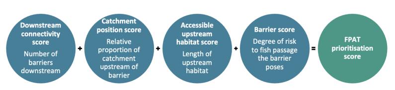
The FPAT prioritisation score is intended to provide a simplistic indicator of the potential ecological value that may result from remediating a structure. The higher the score, the greater the potential ecological benefits of remediating the structure. The score for any structure is influenced by the location and passability of other structures in the same catchment and can vary as more structures are identified and assessed, or other barriers are removed or remediated. Uncertainty exists in the score if all barriers in a catchment have not been identified or assessed.
Every structure is scored on a scale of 1–5 for each attribute, with the sum being the final FPAT priority score (ie, 5–20). Structures with a low barrier score (ie, very low risk to fish passage) may still have a priority of up to 16 (out of a maximum of 20) if they receive maximum scores for the other three attributes.
Detailed information about how barrier prioritisation scores should be calculated can be found in appendix H (p 71) of the FPAT User Guide (Franklin, 2018) [NIWA, 8.1 MB].
Critical Step D: Manual adjustment of FPAT priority scores
Critical Step D is the final step in structure prioritisation. To ensure all available information has been considered, all structures must include this step, regardless of whether the FPAT has been used or not.
Why do I need to adjust the priority scores?
Once FPAT prioritisation scores have been calculated, a manual adjustment or revision is recommended for every record on a structure-by-structure basis. This is necessary because the FPAT prioritisation score provides only a simplistic indicator of the potential ecological value that may result from remediating a structure. If the score is not considered representative of the potential ecological benefits of remediating a structure, manual adjustment is needed. Manual adjustment requires the assessor to be familiar with the structure of interest (through photographs or site visits) and the characteristics of the catchment (eg, geology, morphology and land cover). Revisions may include the following.
Manual assignments of priority scores: Some FPAT assessments may have been completed that do not have a priority score calculated, due to the assessment not being linked to a digital river network. Manual assignment of scores will need to be made for these scores to be included in prioritisation.
Reduction of priority scores may result when:
- the structure presents a very low risk to fish passage
- the upstream channel is dry
- limited habitat available upstream due to low flow, other barriers being present or pipe networks
- no remediation is required
- barriers downstream require attention first
- more barriers than originally anticipated are identified downstream, reducing the value of remediating a single barrier.
In situ reassessments through stream walks are recommended for structures where site-specific knowledge is lacking. Stream walks allow barriers to be assessed from the stream mouth upstream, at least to where it is practical and safe to walk. Priority scores could decrease at some sites if more barriers are encountered.
Increase of priority scores may result when:
- the structure creates a higher fish passage barrier risk than the calculated score allows for
- large, unobstructed, high-quality habitat and/or catchments are upstream
- threatened species are present in upstream catchment
- artificially low FPAT scores were achieved due to unassessed nearby barriers.
Manual adjustment criteria
Criteria that may need to be considered to complete and update FPAT prioritisation scores are listed below. These are council specific and may not all be relevant or need to be included in every council’s adjustment process.
D-1 Additional information on fish distribution
At step D-1, your council will have identified any instream structures and calculated an FPAT priority score. The next critical step is to find out whether fish distribution records are up to date and complete for streams where structures have been identified and scored (note: fish distribution needs to be considered upstream and downstream of a barrier). Various methods and data sources should be used to fulfil this step.
Regional fish distribution data
Initial information sources about fish distribution are your regional council’s internal knowledge and databases and the New Zealand Freshwater Fish Database (NZFFD). The NZFFD is the repository where most organisations input their fish records and can be sorted by date and location. Local fish distribution data may have been collected as part of State of the Environment monitoring programmes or regional plan schedules of important locations of native and sports fish. Information about target or desirable species, as part of specific catchment restoration programmes, may also hold relevant fish distribution information.
Expert judgement can also provide insight into current fish distributions in your region. Te Mana o Te Wai is an essential part of identifying and monitoring New Zealand’s freshwater fish species and their ecosystems. Engaging with mana whenua, kaumātua and marae communities can not only reveal new information about species distribution, both historic and present day, it develops a deeper understanding of the connection between people and threatened freshwater species and their habitats.
Figure 4: Example of current Bay of Plenty regional dataset identifying known ‘crossing points’ and current fish passage status

National fish distribution data
Once local knowledge has been considered, national fish distribution tools and databases are the next source of information (table 3). This information is generally less targeted and may be outdated, depending on the recency of data that informs the database or model. Councils can apply relevant spatial data (eg, adjust regional boundaries) and temporal filters (eg, most current data) that address ecological objectives and performance standards, to ensure fish distribution information is relevant and more up to date.
Table 3: Potential sources of fish distribution knowledge for documenting and detecting freshwater species at a national level
|
Name |
Type |
Reference |
Comments |
|
Mātauranga Māori |
Anecdotal |
|
|
|
Inanga Spawning database |
Geospatial Database |
NZ Inanga Spawning Sites [Seasketch] |
|
|
Fish Spawning Indicator – National Environment Strategy for Plantation Forestry |
Geospatial Database |
Erosion Susceptibility Classification [ArcGIS] and Fish Spawning Indicator tool [MPI] |
The data contained in these include the New Zealand Freshwater Fish Database [NIWA], predicted occurrence of species, and known habitats of non-migratory species. |
|
Freshwater Ecosystems of New Zealand (FENZ) Database |
Spatial Database |
Leathwick et al, 2010; FENZ |
|
|
New Zealand Freshwater Fish Database |
Geospatial Database |
National Institute of Water and Atmospheric Research |
The New Zealand Freshwater Fish Database [NIWA] is the main resource used and applied by researchers and practitioners nationally to both document and identify freshwater fish occurrence and predict patterns of species distribution. Inherent errors and limitations need to be considered, however, when using this tool. |
|
Predicting distributions of New Zealand freshwater fishes |
Technical report |
Crow et al, 2014 |
|
Source: Modified from Adaptive Environmental Consulting (2020)
Additional sampling
If existing datasets do not provide complete and up-to-date fish distribution coverage, additional sampling is recommended. Guidance on how to sample freshwater fish is provided in STEP 4.
Other metadata
Other metadata that should be considered for providing context for fish distributions may come from datasets that hold information about topography or stream gradients, such as digital elevation models (DEMs), Light Detection and Ranging (LiDAR) or aerial satellite imagery, or in-house photographs.
Apart from ecological values, social and cultural freshwater values might be relevant for fish passage management prioritisation (see www.doc.govt.nz/our-work/maps-and-data).
D-2 Supplementary structure information
To ensure effective and accurate fish passage management, supplementary information on structures may need to be included. Step D-2 can be particularly relevant in identifying additional downstream barriers. Both internal and external data should be considered and may include:
- Toitū Te Whenua Land Information New Zealand and Waka Kotahi NZ Transport Authority asset databases
- council infrastructure databases (eg, stormwater networks and watercourse asset databases). For an example of how council datasets can be joined with FPAT, see the Fish Passage Hub
- hydrological datasets to inform flow regimes of waterways (eg, upstream channel is dry, so prioritisation score may need to be lowered)
- other tools developed to assess fish passage
- expert knowledge, community groups, citizen scientists, environmental non-government organisations (eg, Whitebait Connection), local land owners (eg, farmers, lifestyle block owners). See Fish Passage Hub
- historical fish passage remediation programmes focused on specific species or habitats pre-dating the FPAT protocol that were not able to be loaded into the historic layer of FPAT. See further information about this below.
Inclusion of historical data into the FPAT
If your council holds structure datasets that have not yet been entered into the FPAT database, options are available to have these ingested. Ingesting historical data into the FPAT can be a time-consuming and costly exercise that requires large amounts of manual quality assurance and quality control and post-processing to make formats consistent for ingestion. This is particularly so if many of the compulsory fields are missing, resulting in risk scores not being able to be calculated, thereby undermining the integrity of the dataset as a whole.
Careful planning is needed to make effective decisions about which information will need to be ingested retrospectively and whether other options (ie, reassessment of structures) are preferable.
Tips on adding historical data to the FPAT
- All data fields must be mapped directly to FPAT fields.
- The format of all fields must be checked against FPAT database requirements.
- The consistency of categorical variables with the FPAT categories must be confirmed.
- Data will be loaded to the test version of the FPAT, and error checking completed, including testing of post-processing code, phone app, https://fishpassage.niwa.co.nz/ citizen science user interface and FPAT web tool.
- Any errors that arise must be resolved.
- If records have not been collected using the FPAT app, a data flag to indicate this must be used
- Once the test database is working, the data can be uploaded to the operational version of the database.
Many councils will have existing information on their instream structures and reassessing them with the FPAT is not an option. The ingestion might be more easily done where only targeted information needs to be collected retrospectively.
Christchurch City Council was able to match field photographs to historic fish passage assessment pre-dating the FPAT application and to shift 139 structures from the ‘incomplete’ to the ‘complete’ data category (Instream Consulting Ltd, 2021).
If your council does not use the FPAT, then appropriate steps need to be taken to ensure supplementary structure information is accurate and up to date.
D-3 Other important prioritisation criteria
FMU criteria
Criteria listed in table 1 and Critical Step C may also be applicable for prioritisation of instream structures.
Practical considerations
Inclusion of other council-specific fish passage management criteria is critical for successful prioritisation. The criteria listed in table 1 and Critical Step C provide general guidance only and need to be adjusted by your council to suit your regional context. There will always be area/site-specific practical considerations to take into account, including the following.
- Ease of access to the site: When sites are situated in an isolated area, consider including the fish passage retrofit in a ‘package of works’ to reduce contractors’ travel time.
- Health and safety: When instream structures, such as culverts, are situated down steep embankments, for example, accessing the site may pose a health and safety risk for people involved with installation and maintenance.
- Costs: The costs of remediating a high-priority barrier can sometimes outweigh the benefits of the barrier being remediated. Careful planning and thorough cost-benefit analyses are needed in these situations. Bay of Plenty Regional Council found its largest costs when doing remediation work were staff time and travel costs rather than the costs of the structure remediation itself (E Bocker, Bay of Plenty Regional Council, pers. comm., 15 September 2021).
Consenting and compliance
Any consent requirements for the remediation of a barrier will need to be identified and considered early in the prioritisation process.
Many remediation projects will require consents, adding costs and time to projects. Some consents are triggered by regional plans and can be related to other associated activities (eg, site access, vegetation removal, works on a significant ecological area). Sometimes the remediation methodology meets the definition of ‘weir’ in the NES-F and can require a consent under the NES-F regulations.
More detailed information on consenting can be found in the section ‘Legal requirements’.
Once a potential fish migration barrier has been identified (STEP 1) and prioritised (STEP 2), the next step is to remediate. To ensure changes to a structure are long lasting, improvements need to be thoroughly designed, installed and managed.
Remediation decisions should follow thorough planning and design considerations. Often, several mitigation options exist based on the significant variations in biological and hydrological requirements. Detailed guidance on how to improve and remediate fish passage barriers is given in section 3 of the New Zealand Fish Passage Guidelines (Franklin et al, 2018) [NIWA, 8.7 MB].
Table 4 summarises the main considerations for improving and remediating fish passage barriers with links to relevant documents.
What kind of remediation is necessary?
In general, the following remediation order should be considered.
- Structure removal should always be the first option considered and is the preferred solution for maximising fish passage at existing structures. See table 4 for examples.
- Replacement with a newly built structure designed to meet minimum design standards will likely offer the most sustainable and effective solution. For examples, see section 4 (p 34) in the New Zealand Fish Passage Guidelines (Franklin et al, 2018) [NIWA, 8.7 MB] or table 4.
- Modification of existing structures. If a barrier cannot be removed or replaced, it can usually be modified to allow fish to pass. Deciding on the best modification depends on the existing structure, the cost, accessibility, how it is impeding fish passage and the ecological objectives for the site. It is also important to choose a proven method to fix fish passage and install it correctly.
Principles of good fish passage design
All fish passage barrier remediation should be based on the following principles of good fish passage design:
- efficient and safe upstream and downstream passage of all aquatic organisms and life stages with minimal delay or injury
- a variety of physical and hydraulic conditions that lead to a high diversity of passage opportunities
- a structure that provides no greater impediment to fish movements than adjacent stream reaches
- continuity of geomorphic processes, such as the movement of sediment and debris
- structures that need minimal maintenance and are durable.
Remediation generally includes:
- construction of new instream structures, or
- alterations to existing instream structures, or
- design of built and/or intentional structures.
Consideration on best practice guidance
It is important that best practice is followed where possible when remediating fish passage barriers (for examples, see table 4). It should be noted that fish passage remediation currently involves various techniques, including novel solutions not yet completely assessed in the New Zealand context (ie, some retrofitting solutions have not been monitored before and after implementation). If new remediation options are used or proposed, monitoring is critical to ensure effective fish passage remediation is being applied and to track if changes are needed.
Table 4: List of resources available for further information on the removal, modification and replacement of fish passage barriers
|
Type of remediation and information |
Type of remediation applied |
Title of resource |
Source |
Link |
|
|
NEW INSTALL OR REPLACEMENT |
Installation of new instream structure |
Design requirements of new instream structures |
New Zealand Fish Passage Guidelines – section 4 New Zealand Fish Passage Advisory Group |
https://niwa.co.nz/sites/niwa.co.nz/files/NZ-FishPassageGuidelines-upto4m-NIWA-DOC-NZFPAG.pdf |
|
|
REMEDIATION |
Remediation of existing structures |
Design requirements for remediation of existing structures How to fix fish passage barriers Lessons Learnt 1 – Installation of a fish ramp and baffles to restore fish passage at a perched culvert Lessons Learnt 11 – Floating fish ramp provides passage for inanga in Irongate Stream |
New Zealand Fish Passage Guidelines – section 5 New Zealand Fish Passage Advisory Group |
https://niwa.co.nz/sites/niwa.co.nz/files/NZ-FishPassageGuidelines-upto4m-NIWA-DOC-NZFPAG.pdf |
|
|
RETROFITTING |
Retrofitting weirs to create fish ramps |
Lessons Learnt 7 – Retrofitting weirs to create fish ramps in Gibbons Creek, Hamilton |
New Zealand Fish Passage Advisory Group |
||
|
REMOVAL |
Barrier removal |
Lessons Learnt 9 – Ford removal and replacement with a bridge at Wainora Stream (Kauaeranga Valley), Coromandel |
New Zealand Fish Passage Advisory Group |
||
|
GENERIC |
Case studies, factsheets, guidance on fish passage management in New Zealand |
Fish passage resources |
Department of Conservation |
https://www.doc.govt.nz/nature/habitats/freshwater/fish-passage-management/resources/ |
|
|
GENERIC |
Removing, modifying and replacing a barrier |
Fixing barriers to fish passage |
Department of Conservation |
|
|
|
MAINTAIN |
Maintaining or building a barrier |
Maintain or building a barrier |
Department of Conservation |
|
|
Design considerations for new instream structures
The optimal structure for fish passage should be determined as part of the design process and will depend on the purpose of the structure and local conditions. Detailed information on design processes and requirements for new instream structures is given in section 4 of the New Zealand Fish Passage Guidelines (Franklin et al, 2018) [NIWA, 8.7 MB].
Any new instream structure must be properly designed and constructed to allow appropriate fish passage upstream and downstream. The order of preference for road crossing structures up to 4 metres high is often based on the degree of connectivity that each design facilitates (figure 5).
Figure 5: Order of preference for road crossing design based on the degree of connectivity each design facilitates
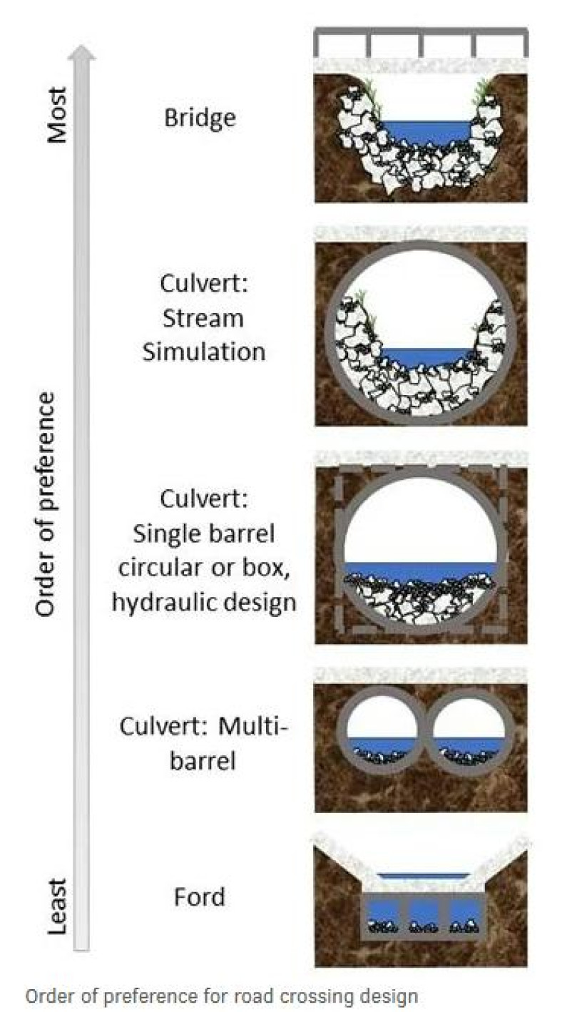
Design considerations for remediation of existing instream structures
In general, site remediation options will depend on many factors, including the characteristics of the existing structure, cost, accessibility, the reason(s) for reduced fish passage and the site’s ecological objectives. To develop site-specific solutions, structure characteristics and the nature of the fish passage problem will need to be individually evaluated. Detailed information about design requirements for existing instream structures is given in section 5 of the New Zealand Fish Passage Guidelines (Franklin et al, 2018) [NIWA, 8.7 MB] or in the summary document ‘How to fix fish passage barriers at existing instream structures [DoC, 753 KB]’ from the New Zealand Fish Passage Advisory Group (2020).
Table 5 outlines methods that might be most suitable to remediate fish passage, based on common problems encountered at barriers.
Table 5: Possible remediation techniques for common problems encountered at barriers
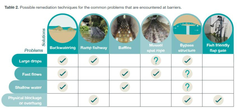
Once a potential fish migration barrier has been identified and prioritised for remediation, the next steps are to set objectives and performance standards for the structure, confirm consenting and permitting requirements, and identify appropriate remediation options for achieving those objectives.
In general, good practice remediation designs include the following elements (see the noted sections of the New Zealand Fish Passage Guidelines [NIWA, 8.7 MB] for further detailed information (Franklin et al, 2018).
- Removal or replacement of structures: Removal is the most effective fish passage remediation option available for existing structures. Where this is not feasible, replacement with a good-practice design should be considered (section 5.3.1, p 76).
- Ramp fishways: Ramps have been widely used throughout New Zealand for overcoming barriers more than 2 metres in height, and have also been used for higher barriers. The two commonly used fishway designs are ‘nature-like’ rock ramps and artificial ramps (eg, concrete rock ramps, artificial substrate ramps) (section 5.3.2, p 77).
- Baffles and mussel spat ropes: Baffles have often been used to modify uniform high-flow velocity conditions in culverts or across weirs to improve fish passage. They are commonly used in culverts (more than 1.2 metres in diameter) to create a low velocity zone. In smaller culverts (less than 1.2 metres in diameter), mussel spat ropes are often used to facilitate upstream passage of juvenile fish. Baffles can also be used to control high water velocity for weirs (section 5.3.3, p 85).
- Bypass structures: If structural adjustments, such as the addition of baffles, are unsuitable to improve fish passage, bypass structures that provide an alternative path past a barrier are recommended. The two main types of bypass structures are ‘nature-like’ fishways and technical fishways (section 5.3.4, p 94).
- Fish friendly tide and flood gates: Fish passage is improved through self-regulating mechanisms that delay gate closing, prolonging the period in which the gate is open and minimising the time the gate is closed (section 5.3.5, p 96).
- A combination of remediation techniques for stormwater management ponds and vertical risers: Commonly used as outlets in existing stormwater retention ponds, vertical risers are standpipes that create a complete barrier to upstream fish passage. General design principles to remediate this barrier include using baffled substrate, incorporating a wetted margin, a maximum gradient of 15 degrees and including resting pools at every metre of vertical gain (section 5.3.6, p 97).
Design considerations for intentionally built barriers
The use of intentionally built barriers (less than 4 metres in height) as a management tool for protecting the locations and habitats of important species has increased in recent times. Several successful built barriers have now been designed, installed and maintained in locations around New Zealand (see examples on the Fish Passage Hub). Most species that would benefit from an intentionally built barrier to ensure survival and security are found in the South Island, mainly Canterbury, Otago and Southland. Table 6-1 (p 101) in the New Zealand Fish Passage Guidelines [NIWA, 8.7 MB] lists the main non-migratory galaxias that could have increased protection from a natural or intentionally built barrier (Franklin et al, 2018).
More specific information on intentionally built barriers is given in section 6 in the New Zealand Fish Passage Guidelines [NIWA, 8.7 MB] (Franklin et al, 2018).
Why monitor?
Monitoring is required to:
- evaluate whether the structure is compliant with specified objectives and performance standards, as set out in legislation
- check the structure is in good condition and functioning as intended or maintenance is required.
Every council will have to prove that target attribute states and environmental outcomes are achieved in a fish passage action plan (NPS-FM 2020, section 3.15). Instream structures need to always provide fish passage under the Freshwater Fisheries Regulations 1983, and failure to ensure effective fish passage is maintained will often result in structures becoming non-compliant with regional planning rules that require fish passage.
Consent exemptions
Councils can apply to the Department of Conservation for an exemption from the requirement to maintain a culvert or ford to allow fish passage; to determine if a fish facility is required when proposing a dam or diversion structure; or approval to modify an existing fish facility required under Freshwater Fisheries Regulations 1983 for dams or diversion structures (see Fish Passage Authorisations on the Department of Conservation website).
Evaluate effectiveness of remediated structures – how to meaningfully assess and report progress
Monitoring is the only way to understand how well a structure is working. A lack of ongoing maintenance can result in the development of fish passage barriers over time, such as major scour and erosion at the discharge end of culverts or vegetation and debris causing obstructions. Even when best practice guidelines are followed, it is important to adopt a monitoring programme to ensure a structure or remediated structure is fit for purpose and operating as designed. Monitoring is important when fish passage solutions form only one part of an instream structure (eg, remediating a perched culvert with a rock ramp will provide access for fish to the culvert outlet, but the culvert barrel itself may present a further migration barrier).
It is important to understand these planning considerations where:
- high-value fish communities and/or ecosystems are present (or have the potential to be present) upstream and downstream of the structure
- unproven designs are being used
- proven designs are being used in novel situations
- retrofitted solutions form only one part of an instream structure
- multiple structures exist within a waterway causing cumulative effects
- selective barriers are being used to manage the movement of undesirable species.
Testing the effectiveness of each part of an instream structure will provide certainty as to whether fish are effectively passing the overall structure and consequently enhancing upstream fish communities.
Who should be monitoring and maintaining structures?
In most instances, it is the structure’s owner or occupier and/or the consent holder’s responsibility to ensure fish passage is provided over the life of a structure.
The NPS-FM 2020 (section 3.26(7f)) requires regional councils to specify how the ongoing performance of remediated structures will be monitored and evaluated as a mandatory part of the Fish Passage Action Plan. The NPS-FM 2020 (section 3.264(e)) also requires regional councils to have regard to any proposed monitoring and maintenance plans for instream structures requiring resource consent. However, the NPS-FM 2020 does not set out expectations on the ‘who and how’ this monitoring would be done, these details are for councils to define in their fish passage action plan.
Similarly, regulation 69 in the NES-F requires consent holders to monitor and maintain new instream structures. Any fish passage facility required at a dam and diversion needs to be monitored by the applicant, and any structural changes in approved fish passage facilities need approval from the Department of Conservation (reg 43, Freshwater Fisheries Regulations 1983). The same rules apply for culverts and fords (reg 42, Freshwater Fisheries Regulations 1983). Should any of these instream structures not require provision for fish passage, applicants, structure owners and/or occupiers should apply for exemptions (reg 41, Freshwater Fisheries Regulations 1983).
For more information on legal requirements, see ‘Legal requirements’.
Citizen science monitoring
Although the responsibility of instream structure maintenance and monitoring often lies with councils, great potential exists for regional councils to include private land owners, communities, or mana whenua in the monitoring of instream structures and fish communities. Collaboration not only allows members of the public to play an important role in the restoration of their local awa but encourages relationships between land owners and council staff to be formed
What should be monitored?
For monitoring to be effective, monitoring outcomes need to be linked to the objectives and performance standards (see STEP 1) set for a structure or site. Councils will need to have a clear understanding of what it means to ‘provide fish passage for a site’ (eg, if it is improving fish passage for a specific species only or clearing up downstream passage for all species in the catchment).
Regarding monitoring, the NPS-FM 2020 (section 3.26 (7)(f)) refers to “…including the effects of the structure on the abundance and diversity of desirable fish”. However, monitoring fish communities without continuously assessing the integrity and functioning of the structure will not provide an integrated measure of effectiveness of the remediation. Monitoring fish passage success at a remediated structure should, therefore, aim to assess:
- the abundance and composition of fish communities upstream and downstream of a structure
- that structural and functional integrity are being preserved.
Council example
Environment Canterbury’s consent to install barriers to fish passage to protect threatened populations of native fish and invertebrates includes the following consent condition on post-construction monitoring.
Post-construction
17. The consent holder shall ensure that the structure is:
- kept free from accumulated debris so that the flood carrying capacity of the waterway is not impaired; and
- maintained in good working order.
18. The Canterbury Regional Council may annually, on the last five working days of May or November, serve notice of its intention to review the conditions of this consent for the purposes of dealing with any adverse effect on the environment which may arise from the exercise of this consent.
19. The lapsing date, for the purposes of section 125 of the Resource Management Act, shall be 30 December 2020.
Monitoring methods
Various monitoring methods can be used to evaluate the effectiveness of retrofit solutions for enhancing fish passage, to make sure they are fit for purpose and fulfilling objectives for improving upstream fish communities. Monitoring increases certainty for councils and/or other land owners that investments in fish passage solutions are optimised and effective. Monitoring methods to assess fish communities include:
- before-after-control-impact (BACI) survey
- in situ mark and recapture study
- environmental DNA (eDNA).
With the broadening of remediation programmes within your region to potentially hundreds of structures, it may become unfeasible to do extensive monitoring, which is often in addition to other fish distribution monitoring. It may be necessary to prioritise monitoring remediated structures, similar to the process for choosing which structures to remediate first (see table 1 and table 2).
Other monitoring methods, such as biotelemetry studies and fish counters, can also be used, but they generally require a higher investment in resources and have severe limitations in monitoring small-bodied fish with a slim morphology (ie, juvenile galaxiids). Simpler methods, such as visual checks, can also be used but can be subject to observer bias and a lack of reproducibility so are not recommended.
The main benefits and drawbacks of various monitoring approaches are listed in table 7.1 (p 123) in the New Zealand Fish Passage Guidelines (Franklin et al, 2018) [NIWA, 8.7 MB].
Novel monitoring techniques – eDNA
In addition to the above monitoring techniques, modern technologies have allowed novel sampling approaches to be developed, such as detecting fish species presence through eDNA analysis (see Banks et al, 2020; David et al, 2021). Detecting fish species presence through eDNA analysis is a passive collection method most suitable for capturing the presence of species upstream of the sampling location. Standardised sampling protocols are still being refined for eDNA sampling (see ‘Wilderlab’ below). This means this sampling technique should be implemented with caution. Some of the drawbacks include that the data is presence-absence type data and does not give abundance and size information. This means the method will not tell you if suitable recruitment is happening above a remediated structure unless the barrier is a complete barrier. Furthermore, results may depend on river flow patterns, so if flows are too high or too low, DNA may not be picked up in samples. Likewise, fish presence-absence is also dependent on DNA degradation over time, meaning that even if fish species occur upstream of the sampling location, it might not get picked up. Therefore, we recommend a combination of novel and well-tested sampling methods.
Wilderlab
Wilderlab (www.wilderlab.co.nz) is still working to find the best standard protocol. At this stage, 6 syringe samples immediately upstream and another 6 taken 150 m downstream – during peak migration time – provide a good assessment of which species are making it up. This methodology has provided at least 90% fish species detection with a range of approximately 5 km. This also allows for a 150 m electrofishing pass or other sampling if results are to be compared. The other method that can be considered is drogue passive samplers that are left overnight. This method is still in early development and does not have the same testing yet. Due to costs of eDNA sampling, it is suggested even though drogue sampling is still not fully proven it is hopefully sufficient as a complementary method, and from results so far looks promising.
(S Bowie, Department of Conservation and C Brent, Auckland Council, pers. comm., 1 September 2021).
Further information on monitoring fish passage success is given in section 7 of the New Zealand Fish Passage Guidelines (Franklin et al, 2018) [NIWA, 8.7 MB].
Monitoring tools and processes for structures
Fish Passage Assessment Tool
The FPAT is a crucial monitoring tool for assessing the integrity of structures and their risk to fish passage over time. Further information on the FPAT as a monitoring tool can be found here [NIWA].
Compliance monitoring
See ‘STEP 4 – Who should be monitoring’ and ‘Legal requirements’.
Combination of survey methods
For fish distribution surveys to be most accurate and robust, we recommend using a combination of sampling techniques, time and resource permitting. These include electrofishing, spotlighting and netting, alongside environmental DNA sampling.
How often should structures be monitored?
At a minimum, all instream structures should be checked annually or after significant natural events, to ensure required objectives of the structure and fish passage are still being met. Due to often occurring site-specific conditions (eg, specific flow regimes, threatened fish community), monitoring frequency should be adjusted to these unique conditions and may need to occur more frequently. Priorities should be given to sites and structures that fall within priority freshwater management programmes or align with priority values (eg, exemplar catchments, significant sites of interest) (see ‘STEP 1 – Identify FMUs’).
To ensure responsibilities are clear from the start, monitoring decisions are best discussed with relevant stakeholders (eg, mana whenua, land owners, asset owners).
Council and Department of Conservation examples on monitoring of remediated barriers are shown on the Fish Passage Hub. Further information on freshwater fish sampling protocols is given in the New Zealand Freshwater Fish Sampling Protocols (Joy et al, 2013) [NIWA, 9.4 MB] and the Department of Conservation’s Freshwater fish inventory and monitoring website.
Council examples
Northland Regional Council implemented a ‘Traffic light coding system’ that provides an easy snapshot of the stage its fish passage structures are currently in.
- Red – structure identified, asset number and asset owner details provided.
- Amber – date remediation works were recommended, set timeframe for works and due completion date.
- Green – date work was completed on the instream structure and resource consent reference, if applicable.
Standard reporting requirements
When managing fish passage, every council must identify the sites to be used for monitoring (NPS-FM 2020, section 3.8(3a)). To achieve the environmental outcomes (in this case river connectivity) for these sites, every regional council must:
- set a target attribute state for every attribute identified for a value
- identify the site or sites to which the target attribute state applies.
To align with the New Zealand’s environmental reporting series, we recommend the use of a ‘Pressure-State-Impact Framework’ for presenting information, using the following metrics for target attribute setting:
- pressure: number of barriers, total recorded, total assessed or not assessed, total newly assessed, total remediated, how much habitat opened up
- state: river connectivity, for example, proportion of river network connected or not connected versus unknown; proportion of habitat with low, very low risk structures and high or very high risk structures, length of habitat (re-)opened to migratory fish.
Pressure = something that influences (and can explain) change in the state of the environment.
State = a measure of the condition of the environment.
Impact = the consequences of changes in the state or condition of the environment. Disruptions to river connectivity (= state) caused by instream structures (= pressure) alter fish abundance and distributions in streams and rivers (= impact).
Risk assessment as a fish passage pressure metric
How risk to fish passage can be evaluated is discussed in ‘STEP 2 – Critical Step B – Identify risk of assessed structures’.
River connectivity as a fish passage state metric
River connectivity should be the preferred measure of environmental state for freshwater environments, and we recommend using the FPAT to calculate this metric.
The FPAT classifies all river reaches according to the barrier with the highest fish passage risk class that occurred downstream, and then calculates the total stream length within each risk class. Once the stream network has been classified into the different risk groups, total stream length in each risk class is calculated and the proportion of the stream network in each class is derived. The greater the proportion of the river network in the higher risk classes, the poorer the state of river connectivity, and the greater the risk of impacts on instream values (see FPAT User Guide (p 68) (Franklin, 2018) [NIWA, 9.6 MB]).
How to specify a timeframe for achieving river connectivity
Generally, changes to regional policy statements and regional plans required by the NPS-FM 2020 are to be made by regional councils ‘as soon as reasonably practicable’. However, a plan change giving effect to the NPS-FM 2020 must be notified no later than 31 December 2024 under section 80A(4)(b) of the Resource Management Act 1991 using the freshwater planning process that provides for public input.
Most councils have started formulating or are well into preparing plans to address fish passage requirements in their regions.
Council example
Northland Regional Council anticipates the following timeline:
- establish working groups by July 2021
- identify priority areas by end of 2021
- work to start on structures by March 2022.
How to report and review
All monitoring information needs to be captured in a detailed and consistent way (see section 7 (p 122) of the New Zealand Fish Passage Guidelines (Franklin et al, 2018) [NIWA, 8.7 MB]). Every action plan (or part of an action plan) must be reviewed within five years after it has been published (NPS-FM 2020, section 3.15(6)).
Fish Passage Assessment Tool for monitoring
The FPAT also offers a mechanism to record monitoring and maintenance information about instream structures and their remediations (see FPAT User Guide p 36 [NIWA, 9.7 MB]), (Franklin, 2018), including:
- type, date and effectiveness of existing fish passage improvements done at a structure (eg, rock ramp, backwatering, artificial ramp, spat ropes)
- risk of structure to fish passage (eg, very high to very low)
- if the structure protects native species or habitats.
Evaluation of the structure based on its impacts and subsequent actions (ie, remove, replace, remediate).
Adaptive Environmental Consulting. 2020. Identifying the Location of Freshwater Habitats of Threatened Species in New Zealand: A summary of current tools and resources. Report prepared for Ministry for the Environment. Wellington: Ministry for the Environment. Retrieved from https://environment.govt.nz/assets/Publications/Files/identifying-the-location-of-freshwater-habitats-of-threatened-species-in-new-zealand.pdf (19 January 2022).
Auckland Council Healthy Waters Fish Passage Remediation – Planning Assessment Summary; 2021. Prepared for Auckland Council. Prepared by Beca Limited.
Banks J, Kelly L, Clapcott J. 2020. Molecular tools for characterising freshwater fish communities in New Zealand. Prepared for Ministry of Business, Innovation and Employment. Envirolink CAWX 1802. Cawthron Report No. 3573. https://www.smith-root.com/images/smith-root/downloads/CawRpt_3573_Molecular_tools_for_characterising_freshwater_fish_in_New_Zealand.pdf (17 February 2022).
Crow S, Booker D, Sykes J, Unwin M, Shankar U. 2014. Predicting distributions of New Zealand freshwater fishes. NIWA Client Report CHC2014-145. Christchurch: National Institute of Water and Atmospheric Research. Retrieved from https://niwa.co.nz/sites/niwa.co.nz/files/29_nativefishpredictionmaps.pdf (19 January 2022).
David B, Fake D, Hicks A, Wilkinson S, Bunce M, Smith J, West D, Collins K, Gleeson D 2021. Sucked in by eDNA – a promising tool for complementing riverine assessment of freshwater fish communities in Aotearoa New Zealand. New Zealand Journal of Zoology, 48:3-4, 217-244, DOI: 10.1080/03014223.2021.1905672
Department of Conservation. 2022. Designing new instream structures. Retrieved from https://www.doc.govt.nz/nature/habitats/freshwater/fish-passage-management/designing-new-instream-structures/ (25 February 2022).
Franklin P. 2018. Fish Passage Assessment Protocol mobile application – User Guide. Prepared for Envirolink Tools. Hamilton: National Institute of Water and Atmospheric Research. Retrieved from https://niwa.co.nz/sites/niwa.co.nz/files/User%20guide%20v1.3%20FINAL.pdf (19 January 2022).
Franklin P, Gee E, Baker C, Bowie S. 2018. New Zealand Fish Passage Guidelines for Structures up to 4 metres. Hamilton: National Institute of Water and Atmospheric Research. Retrieved from https://environment.govt.nz/publications/new-zealand-fish-passage-guidelines-for-structures-up-to-four-metres/ (19 January 2022).
Instream Consulting Ltd. 2021. Prioritisation of fish barriers for remediation in Christchurch. Prepared for Christchurch City Council. Christchurch: Instream Consulting Ltd.
Jones G. 2009. The Adaptive Management System for the Tasmanian Wilderness World Heritage Area. Linking Management Planning with Effectiveness Evaluation. In: C Allan and G Stankey (eds) Adaptive Environmental Management: A Practitioner’s Guide. Dordrecht, The Netherlands and Collingwood, Australia: Springer and CSIRO Publishing.
Joy M, David B, Lake M. 2013. New Zealand Freshwater Fish Sampling Protocols. Palmerston North: Massey University. Retrieved from https://niwa.co.nz/static/web/New_Zealand_Freshwater_Fish_Sampling_Protocols.pdf (24 February)
Leathwick J, West D, Gerbeaux P, Kelly D, Robertson H, Brown D, Chadderton W, Ausseil A-G. 2010. Freshwater Ecosystems of New Zealand (FENZ) database. Wellington: Department of Conservation. Retrieved from https://www.doc.govt.nz/our-work/freshwater-ecosystems-of-new-zealand/ (19 January 2022).
Ministry for the Environment. 2016. A Guide to Identifying Freshwater Management Units under the National Policy Statement for Freshwater Management 2014. Wellington: Ministry for the Environment. Retrieved https://environment.govt.nz/assets/Publications/Files/guide-to-freshwater-management-units_0.pdf (24 February 2022).
National Institute of Water and Atmospheric Research. 2020. Freshwater invasive species of New Zealand 2020. Retrieved from https://niwa.co.nz/sites/niwa.co.nz/files/Freshwater%20invasive%20species%20of%20New%20Zealand%202020_0.pdf (19 January 2022).
New Zealand Fish Passage Advisory Group. 2020. How to fix fish passage barriers at existing instream structures. Wellington: Department of Conservation. Retrieved from https://www.doc.govt.nz/globalassets/documents/conservation/native-animals/fish/fish-passage/how-to-fix-fish-passage-barriers.pdf%20 (16 March 2022).
Stats NZ. 2021. Extinction threat to indigenous freshwater species. Retrieved from https://www.stats.govt.nz/indicators/extinction-threat-to-indigenous-freshwater-species (24 February 2022).
See more on...
Fish passage action plan guidance
April 2022
© Ministry for the Environment